Samuel H. Boardman Corridor Oregon Coast Road Trip
This post may contain affiliate links. I may earn a small commission at no extra cost to you.
Samuel H. Boardman Corridor: Oregon's Hidden Coastal Treasure
The Samuel H. Boardman Scenic Corridor is a 12-mile stretch of protected Oregon coastline between the towns of Coos Bay and Brookings on the South Coast. Unlike the crowded beaches near major cities, this corridor remains a genuine surprise for road-trippers who venture south—and it deserves a deliberate stop on any Oregon Coast itinerary, not a rushed drive-by.
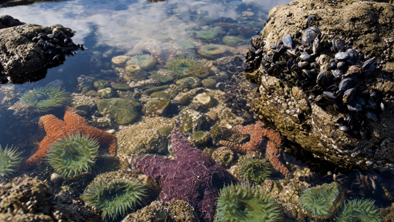
What makes Boardman special is not one landmark but a series of them: towering sea stacks, hidden coves, tide pools teeming with starfish and anemones, and sweeping ocean views that shift every few hundred yards. In spring, the bluffs explode with wildflowers—lupine, Indian paintbrush, and coastal buckwheat—while gray whales migrate north past the headlands. The corridor is also remarkably less crowded than Cape Perpetua or Ecola State Park, which means you can actually park, walk, and explore without fighting for space.
Why Spring Is Prime Time for Boardman
Spring (March through May) transforms the Boardman Corridor into a naturalist's paradise. Gray whales begin their northbound migration from Baja California in mid-February and continue through May, with peak viewing typically in April and early May. From the high bluffs and accessible viewpoints, you can spot whale spouts, dorsal fins, and occasionally breaching behavior without a boat tour.
Wildflowers peak in April and May. The coastal bluffs here support unique plant communities adapted to salt spray and wind, creating dense mats of color. Lupine dominates, but you'll also see delicate coastal phlox, golden balsamroot, and the distinctive orange blooms of Indian paintbrush. Photographers and botanists find this window irresistible.
Spring weather, however, is volatile. Expect sunny mornings followed by afternoon showers, occasional fog, and wind gusts that can exceed 30 mph. Temperatures typically range from 48°F to 58°F. Layering is essential—bring a windproof jacket, even if the morning feels mild.
Driving and Timing: How to Structure Your Stop
The Boardman Corridor lies on U.S. Route 101, roughly 35 miles south of Coos Bay and 20 miles north of Brookings. The scenic drive through the corridor itself takes 25–35 minutes at a leisurely pace if you stop at major viewpoints. If you plan to hike or spend time at tide pools, budget 2–4 hours total.
From the north: If you're traveling from Coos Bay, the corridor begins near the town of Bandon. Parking areas are marked along the highway; the first major pullout is at Face Rock Scenic Viewpoint (just outside Bandon proper, not technically in the corridor but a natural starting point). The corridor proper extends south from there.
From the south: If you're coming from Brookings, you'll enter the corridor from the south and drive north; the experience is equally rewarding in reverse.
Key viewpoints within the corridor include:
Cape Arago Lighthouse viewpoint (north end): A short walk to views of the historic lighthouse and offshore rocks. Whale spouts are often visible from here in spring.
Sunset Bay State Park (just north of the corridor proper): A protected cove with sandy beach, picnic facilities, and restrooms. This is a good lunch or break spot.
Shore Acres State Park (slightly inland, near Coos Bay): A botanical garden perched on a headland. Worth a 30–45 minute detour if you love cultivated coastal gardens alongside wild ocean views.
Boardman Lake viewpoint (mid-corridor): A small parking area with views of a freshwater lake nestled behind coastal dunes—unusual and photogenic.
Arch Rock (south-central corridor): A natural sea arch visible from a roadside pullout. Accessible and dramatic.
Natural Bridges viewpoint (south-central): A short walk to views of wave-carved rock formations and tide pools below (accessible only at low tide).
Lone Ranch Beach (south end): A sandy beach with parking, picnic tables, and restroom facilities. The easiest full-beach access in the corridor.
Parking and Facilities: What to Expect
Unlike state parks with centralized parking and visitor centers, the Boardman Corridor relies on small pullouts and informal parking areas along U.S. 101. This is both a blessing (less crowding) and a logistical challenge.
Parking availability: Most viewpoints have 5–15 parking spaces. During peak season (summer) and weekends, popular spots can fill by mid-morning. Spring shoulder season is less crowded, but don't assume you'll find a spot immediately—be prepared to try a second viewpoint if the first is full.
Restroom access: This is critical information often missing from casual road-trip guides. Restrooms are not available at most Boardman viewpoints. Your best options are:
• Sunset Bay State Park (has restrooms and picnic facilities)
• Lone Ranch Beach (has a small restroom facility)
• The towns of Bandon (north) or Brookings (south), both 15–20 minutes away
If you have children or limited bladder capacity, plan your stop timing accordingly. Use the restroom in Bandon or Brookings before entering the corridor, or time your visit to include a Sunset Bay or Lone Ranch Beach stop.
Cell service: Spotty. Verizon and T-Mobile coverage exists but is unreliable in some areas. Download offline maps and any weather information before you arrive.
Tide Pools, Wildflowers, and Whale Watching: What to Do
Tide pools: Several viewpoints offer tide-pool access, but only at low tide. Check tide tables before you visit (NOAA provides free tide predictions for Oregon coastal areas). The best tide-pool windows are 2–3 hours before and after the lowest tide. Wear sturdy, water-resistant shoes with good grip. Never turn your back on the ocean, and be aware that waves can surge unexpectedly into pools. See our Oregon Coast tide pool guide for detailed etiquette and safety.
Wildflowers: Bring a wildflower identification guide or use a plant-ID app like iNaturalist. The bluffs are fragile—stay on marked trails and don't trample vegetation to get photos. Many of these plants are adapted to harsh coastal conditions and recover slowly from damage.
Whale watching: Binoculars are invaluable. Early morning (7–9 a.m.) often offers the clearest visibility and calmest ocean conditions. Look for spouts (a distinctive spray of water and mist), dark backs breaking the surface, or the characteristic shape of a whale's tail flukes. Gray whales are typically 40–50 feet long, so they're visible from shore if you know what to look for. Our Oregon Coast wildlife guide has detailed whale-identification tips.
Weather, Safety, and Seasonal Considerations
Spring weather volatility: Boardman is exposed to Pacific storms and wind. A sunny morning can turn foggy and rainy by afternoon. Check the National Weather Service forecast for Coos County before you leave, and bring rain gear even if the forecast looks clear.
Wind and cliff safety: The bluffs are high and exposed. Wind gusts can exceed 30 mph in spring. Keep children and pets close, especially near cliff edges. Never lean over railings or venture beyond marked trails to get a better photo.
Ocean hazards: Sneaker waves are a real danger on exposed Oregon beaches. Never turn your back on the ocean, never wade into the water, and never assume a calm moment means the ocean is safe. One unexpected surge can pull you in. More details are in our Oregon Coast weather planning guide.
Wildlife: Harbor seals, sea lions, and bald eagles are common. Observe from a distance; never approach animals or block their access to the water.
Seasonal lodging: Spring is shoulder season, so lodging in Bandon and Brookings is less expensive and more available than summer. However, some smaller inns close in winter, so book ahead. Coos Bay offers more chain-hotel options if you prefer familiarity.
Planning Your Road Trip: Before and After Boardman
The Samuel H. Boardman Corridor fits naturally into a larger South Coast loop. If you're traveling from the north, consider stopping at Cape Perpetua or Sea Lion Caves (both between Lincoln City and Coos Bay) before heading south. If you're continuing south, Brookings offers the Azalea Park (peak bloom in April–May), the Chetco River, and access to the California border.
A typical South Coast road trip might look like this:
• Day 1: Drive from Portland or Salem to Coos Bay (5–6 hours); explore Sunset Bay State Park and Shore Acres.
• Day 2: Spend 3–4 hours in the Samuel H. Boardman Corridor, stopping at 4–6 viewpoints, then drive to Brookings (1.5 hours).
• Day 3: Explore Brookings, the Azalea Park, and nearby hiking or return north.
If you're planning a longer road trip, our Oregon Coast road trip guide covers multi-day itineraries and regional connections.
Practical Packing and Rental Considerations
For a Boardman Corridor stop, pack:
• Layered clothing (fleece, windproof jacket, hat)
• Binoculars for whale watching
• Sturdy, water-resistant hiking shoes
• Sunscreen and lip balm (ocean reflection intensifies UV exposure)
• A tide-table printout or app
• A wildflower guide or plant-ID app
• Snacks and water (no food vendors in the corridor)
• A camera with a zoom lens if you plan serious wildlife photography
<!– ocj-affiliate-inline:ocj_lodging_finder –>
If you are building a weekend around this part of the coast, compare nearby lodging before finalizing the route. This can be especially useful around the South Coast when weather, daylight, and driving time affect the plan.
Where to stay near this Oregon Coast stop
If you are building a weekend around this part of the coast, compare nearby lodging before finalizing the route.
This article may contain affiliate links. Oregon Coast Journey may earn a commission if you book or buy through these links, at no extra cost to you.
Compare nearby stays through approved partners such as Booking.com, Travelpayouts lodging partners.
If you're renting a car for your Oregon Coast road trip, a standard sedan works fine for U.S. 101. If you're considering an RV, note that the corridor has no RV-specific facilities; Sunset Bay State Park has an RV campground nearby (about 20 minutes north), which is a good base for exploring Boardman.
FAQ
Q: When is the best time to see migrating gray whales at Boardman? A: Mid-April through early May offers the most consistent sightings. Whales migrate north from Baja California starting in February, but April and May see the heaviest traffic. Early morning and calm days offer the best visibility.
Q: Are there restrooms along the Boardman Corridor? A: Most viewpoints don't have restrooms. Sunset Bay State Park and Lone Ranch Beach have facilities. Plan to use restrooms in Bandon or Brookings before or after your corridor visit.
Q: Can I access tide pools at all times? A: No. Tide pools are only safely accessible at low tide, typically 2–3 hours before or after the lowest tide of the day. Check NOAA tide predictions before you visit.
Q: Is the Boardman Corridor safe in spring weather? A: Yes, if you're prepared. Bring rain gear, watch for wind, and never turn your back on the ocean. Avoid cliff edges in high wind, and check the weather forecast before you leave.
Q: How long should I spend at the Boardman Corridor? A: A quick drive-through takes 25–35 minutes. To enjoy viewpoints, walk short trails, and explore tide pools, budget 2–4 hours. Spring wildflower and whale-watching season justifies a full half-day stop.
AI Assistance Disclosure
This article was written with AI assistance. Research, structure, and practical recommendations are based on Oregon Parks and Recreation Department resources, Travel Oregon guides, NOAA tide and weather data, and established Oregon Coast safety practices. All specific location names, distances, and seasonal timing reflect real geography and documented natural patterns. Recommendations for safety, weather preparedness, and wildlife observation align with official guidance from state parks and wildlife agencies. Human editorial review ensured accuracy and relevance to Oregon Coast road-trip planning.
Editorial transparency
This article was drafted with AI assistance and reviewed through Oregon Coast Journey publishing safeguards. Always confirm current conditions before traveling.
Free: Pacific Coast Cruise Planning Checklist
Grab my free step-by-step checklist for planning an Alaska, Mexican Riviera, Hawaii, or Pacific Coastal cruise — sent straight to your inbox.